Where am I?
Date written: 02/03/21
Days in: 4
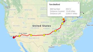
Current location: Chicago, IL
Distance traveled: 19.94 miles
Distance left: 2251.51 miles
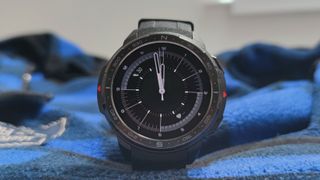
Current tracker: Honor Watch GS Pro
In the mid-20th century, countless people travelled down US Route 66, travelling from east to west in pursuit of new fortunes. And almost exactly 95 years after the route number was designated, I’m stepping foot upon the road too, albeit in a very different way.
I won’t give you a full history lesson here, but for the uninitiated, Route 66 started in Chicago, and travelled through eight states to end in Los Angeles nearly 4,000km or 2,500 miles down the road – it was most used during the Dust Bowl and Great Depression, by people seeking their fortunes out west. It was in use from 1926 to 1985, but you can’t physically travel the entirety of the road any more, as many segments have been closed – I’m not travelling the thing physically, though.
I’m actually travelling the length of Route 66 virtually, in a series of chunks over the course of two years.
You could probably class me as an amateur runner – I’m certainly not a beginner, with a few half-marathons under my belt, and I go on short 8km or 13km trips a few times a week. But ‘a few short trips per week’ won’t get me far on Route 66, and to manage the whole route in two years, my stamina – and knowledge of tech – is going to be tested.
Why Route 66?
My decision to run Route 66 wasn’t exactly a random decision. It’s actually one of many challenges run by website End to End, which has other challenges too like ascending the height of Everest.
The way it works, is that every time I go on a run (or walk, or cycle – you have three different modes of travel you can use), I’ll log my distance on the site (using a printscreen from whatever wearable or workout-tracking app I’m using as proof). Then, I’ll get to see on a map of the US to see how far I am along the route.
This map follows the historical Route 66, so whenever I want, I can log in and see how far I’ve got (and jump into street view too). At time of writing I’m on a gray road leading out of Chicago, still near the start of the route, but over time I’ll venture through eight states until reaching the Santa Monica terminus.
The challenge runs for two years after signing up – I’ve got until February 27 2023 to reach Santa Monica Pier – which is quite a tight turn-around given the total distance.
The distance End to End cites for the challenge is 2,278 miles which converts to 3,666km – I’ve been using the latter measurement, simply because the wearables I test for TechRadar do. That converts to about 23.73 miles or 38.19km per week, or to break it down even further, 3.39 miles or 5.46km every single day.
When looking at the overall length of Route 66, it’s very easy to consider it totally traversable, but when you think about traveling 5-and-a-half kilometres every single day, it becomes a little more daunting. There aren’t many rest days available there! I wish I’d done that maths before excitedly signing up, but one afternoon with all my cocky post-run energy, I decided just to sign up to the longest run-route I could find.
So now I’ve got to run roughly three times further per week than I used to, and keep this pace going for 24 months. Fun!
And why am I not running the physical Route 66? Sadly, I don’t live in the US, which rather rules it out, though given how beautiful some stretches of the track look, I really wish I could. Otherwise the first thing I’d do would be, as Chuck Berry sang, to get my kicks on Route 66.
Why technology is fundamental in the venture
Luckily, I’m quite tech’d up, which will (hopefully) be super useful for my two-year venture. I frequently test smartwatches and fitness trackers, and what I don’t get loaned for review purposes, I can buy thanks to TechRadar’s myriad guides on the best tech for various purposes.
There’s no way I – or anyone else for that matter – would be able to do such a challenge without tech (well, other than going on the actual Route 66, of course). Thanks to smartwatches, fitness trackers, or just smartphone apps, anyone can easily track how far they run, which is vital for logging the journey on the End to End website.
I’m crossing my fingers that these trackers are accurate too – while a smartwatch being 1% inaccurate for a short run might seem inconsequential, over 4,000km that’s a whopping 40km difference – extra distance I really don’t want to run!
But tech is more important than that: smartwatches can help us when we’re out and about to keep tabs on our health; headphones can help us keep pace with music or distract from long runs with podcasts; smartphones can capture the scenic places visited and provide on-the-fly mapping information.
I’m hoping my use of tech makes this challenge easier and safer, and hopefully it’ll also get me to appreciate all the gadgets we use every day.
The road ahead
This article isn’t going to be the first documenting my trans-American expedition – I’m going to be writing fortnightly columns detailing my observations, on subjects from wearables to wireless headphones, photography to foodology and more.
Hopefully my observations will be interesting to fellow amateur runners, and I also expect it’ll make me better at testing all the fitness tech I use – but there’s another, more personal (or is that cynical?) reason.
I’m prone to signing up to big ventures, either in spirit (like convincing myself that I’m going to learn banjo) or in person (like signing up for this Route 66 run), then chickening out at the first sign of hardship (having to pay money for a banjo, realising banjo isn’t as cool as I think it is).
If I’m documenting my running challenge for a regular TechRadar column, though, I’m much less likely to give up halfway through – in fact, it’s literally my job to keep going (I’ll tell myself that, at least).
This is the first of many posts, but when more are written, they’ll be shared here, so you can easily find them and learn from, or laugh at, my pursuits.


Comments are closed.